
Imagine stepping into a world where the roar of icy waters fills the air, snow-clad peaks tower all around, and you’re walking to the very source of one of India’s holiest rivers. That is the feeling of the Gaumukh Trek – Ultimate Guide.
Nestled in the Garhwal Himalayas of Uttarakhand, the trek begins in the sacred town of Gangotri (altitude ~3,048 m) and ascends through pine and birch forests to the glacier-snout of Gaumukh (literally “cow’s mouth” of the glacier) at roughly 4,000 m+ elevation. As per official trekking authorities, the route is part of the Gangotri Glacier system and lies in the district of Uttarkashi.

Quick Snapshot
| Item | Details |
|---|---|
| Start point | Gangotri (~3,048 m) |
| End point (one-way) | Gaumukh (~4,023 m) (approx) |
| Trek distance (one-way) | Approximately 18-20 km from Gangotri to Gaumukh (reporting varies) |
| Typical duration | 4-5 days for Gangotri → Gaumukh → return; extended options up to 7-8 days if including Tapovan |
| Maximum altitude | Up to ~4,460 m (for Gaumukh-Tapovan extension) |
| Difficulty level | Moderate to Difficult: Non-technical but high altitude and variable terrain |
| Best seasons | Pre-monsoon (May‐June) & Post-monsoon (Sept-Oct) |
| Permit requirement | Yes — entry into forest/park and glacier zone requires permit (as per forest dept.) |
Why Trek to Gangotri–Gaumukh?
There are few treks in India that combine the sheer wilderness of the high Himalayas and the deep spiritual resonance of the source of the Ganges.
When you arrive at Gangotri, it’s not just another base town — it marks the beginning of the holy river’s physical journey. From here, you walk the land that pilgrims and sages have walked for centuries.
As you ascend through chir pine forests, meadows, and finally the rocky glacier-moraine fields, you feel the altitude, the wind, the raw silence of the mountains. At Gaumukh — the glacier snout of the Gangotri glacier — you arrive at the very mouth of the ice from which the Bhagirathi flows.
Add to that the panoramic views of majestic peaks like Shivling Peak, Bhagirathi I/II/III and the stunning alpine meadow of Tapovan (if you extend). It becomes far more than a trek: it’s a pilgrimage, an adventure, a silent conversation with nature.
For the traveller aged 18-50 eager for meaning with movement, the Gaumukh Trek offers that rare mix of challenge + peace + cultural depth.
Best Time to Visit (Seasonal Breakdown)
Summer (May – June)
This is one of the best windows to trek. Snow from winter begins to melt, the meadows open up, skies are clearer and the trail is accessible. Temperatures at higher camps can still drop near freezing at night, but daytime can be pleasant (15-20 °C in lower altitudes).
Monsoon (July – August)
This period is risky. Heavy rains in the Uttarkashi/Gangotri region increase landslide/rockfall danger, and trails may be slippery. Several sources advise avoiding the trek during peak monsoon.
Autumn / Post-Monsoon (September – October)
Another excellent window: skies are crisp, visibility high, landscape washed clean, fewer clouds. Ideal for those seeking both views and fewer crowds.
Winter (Late October onwards)
Snowfall sets in, many trails and rest-houses close, conditions become technical. Only for highly experienced mountaineers.
Summary: Aim for May–June or September–October for the best mix of safety, scenery and accessibility.
How to Reach the Trailhead
By Air
The nearest airport is Jolly Grant Airport (Dehradun) ~ 30 km east of Dehradun city. Regular flights connect Delhi and a few other major cities. From Dehradun, hire a taxi or share a vehicle to Gangotri.

By Rail
The smallest major railhead is Dehradun Railway Station (DDN) which connects with Delhi and other Indian cities. From there, road onwards to Gangotri.
By Road
From Dehradun city, the route goes via Rishikesh → Uttarkashi → Gangotri. The drive is around ~240-250 km, taking 9-10 hours depending on road conditions.
Once in Gangotri, the trek begins on foot from the forest-checkpost/entry barrier into the national park zone.
Tips:
- Start early from Dehradun/Uttarkashi to beat traffic and reach Gangotri in daylight.
- Road beyond Uttarkashi (towards Gangotri) may be narrow and subject to landslides—check local conditions.
- At Gangotri base you should secure your trek permit/forest entry pass before heading into the trail zone.
Where to Stay
In Gangotri
There are guesthouses, dharamshalas, and simple lodges. Budget range for basic stay + meals: ₹1000-₹2500 per night, depending on comfort.
On the Trail
- At campsites like Chirbasa and Bhojbasa you’ll find forest-department rest houses or camping options.
- At Bhojbasa (~12,400 ft) you may find the only built lodging option before the high-glacier zone.
Budget Ranges
- Budget: Stay in basic dorm or guesthouse in Gangotri, carry your own sleeping bag on trek.
- Mid-range: Lodge + guided camp + meals included (₹15,000-20,000 for full trek depending on duration) per person.
- Premium: Private tents, porter/mule services, custom groups.
Neighbourhood Guide
- Gangotri town: Best for acclimatisation, final gear purchase, local culture.
- Bhojbasa / Chirbasa: Your trail camp zone — minimal amenities, but immerse in raw nature.
- Choose accommodation early if travelling in peak window (May/June or Sept).
Top Things to Do (Route & Highlights)
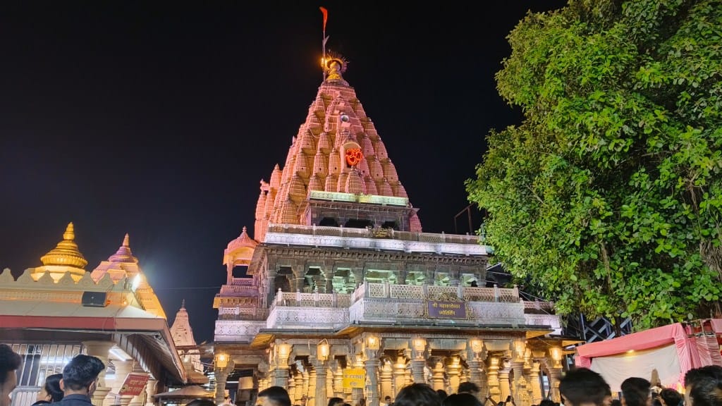
Gangotri Temple & Trailhead

Start your journey at the Gangotri temple complex, perched at ~3,048 m. From here you begin your trek after collecting permits at forest check-points. The evening aarti offers atmospheric Himalayan spirituality.
Chirbasa (Pine Forest Zone)

As you ascend, the forest of chir pines gives way to birch and alpine shrubs. The air thins, and landscapes open up. This is a good place to pause, hydrate and check acclimatisation.
Bhojbasa (Birch Meadows & Ashram Zone)

Around ~12,400 ft – this is a natural meadow encircled by birch trees and the Bhagirathi river roaring beside you. Camp here and witness sunrise light hitting the peaks.
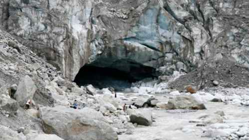
Gaumukh Glacier (Source of Ganga)

The holy target: the snout of the Gangotri glacier, known as Gaumukh (“cow’s mouth”). From here the Bhagirathi emerges — you’re standing at nature’s origin of the Ganges. Altitude ~4,000+ m. Terrain: rocky moraines, glacial ice, boulder fields.
Optional Extension – Tapovan & Shivling Base

For those craving more, ascend beyond Gaumukh to the high-altitude meadow of Tapovan (approx ~4,300-4,600 m) with close-up views of Mt. Shivling. This adds steeper climbs, glacier crossings, and more strenuous terrain.
Offbeat & Local Experiences
- Sunrise at Bhojbasa: Rise early and watch the first rays hit the Bhagirathi peaks — magical silence, few other trekkers.
- Meeting Himalayan sadhus: En route you may encounter Himalayan monks or pilgrims meditating — respectful silence and conversation welcome.
- Birdwatching & alpine flora: Keep an eye out for Himalayan birds and wildflowers in meadows around Chirbasa and Bhojbasa.
- Stargazing from Tapovan: With minimal light pollution, the high meadow offers stunning night skies — bring a headlamp and warm gear.
- Glacier reflections: From Gaumukh you can witness the ice-snout melting, glacier retreat signs and listen to the river’s roar — a raw nature moment.
Suggested Itineraries
1-Day (Gangotri to Bhojbasa and back)
- Day 1: Reach Gangotri early, trek to Bhojbasa (~12 km) and camp.
- Day 2: Trek up to viewpoint (not full Gaumukh), return to Gangotri.
Note: A true Gaumukh round-trip in 1 day is not advisable because of altitude and distance.
3-Day Trek (Gangotri → Gaumukh → Gangotri)
- Day 1: Drive to Gangotri, evening acclimatise.
- Day 2: Trek to Bhojbasa, camp.
- Day 3: Early morning trek to Gaumukh, return to Gangotri.
5-Day Trek (Gangotri → Chirbasa → Bhojbasa → Gaumukh → Tapovan → Return)
- Day 1: Arrive at Gangotri.
- Day 2: Trek to Chirbasa.
- Day 3: Trek to Bhojbasa.
- Day 4: Gaumukh and onward to Tapovan.
- Day 5: Return to Gangotri and depart.
These sample itineraries help you choose based on fitness, time and ambition.
Costs & Budgeting
| Item | Approx Cost (INR) | Notes |
|---|---|---|
| Forest & park permit | ~ ₹500-₹1500 (varies) | As per forest authority — check current rate. |
| Guide/porter (group) | ~ ₹1,000-₹2,500/day | If you hire local support. |
| Shared transport (Dehradun → Gangotri) | ~ ₹9,000 total for shared vehicle | Example from operator data. |
| Accommodation (Gangotri) | ~ ₹1,000-₹2,500/night | Basic guesthouse. |
| Meals on trail | ~ ₹800-₹1,500/day | Depending on group/equipment. |
| Camping + gear rental (tents, sleeping bags) | ~ ₹3,000-₹6,000 | For extended 5-day trek. |
| Miscellaneous (insurance, rescue fund) | ~ ₹500-₹1,000 | Always budget extra. |
| Budget tip: A 4-5 day independent trek (basic gear, shared transport, self-carry) might cost ₹15,000-₹20,000 per person. A guided 7-8 day package may cost ₹25,000-₹35,000+ depending on services. |
Local Transport Guide
- Shared jeeps/taxis: From Dehradun or Uttarkashi to Gangotri are typical. Book in advance.
- Trail transport: Beyond Gangotri everything is on foot; mules/porters may be rented to carry gear, but horses are not typically allowed.
- Trail conditions: After Chirbasa the terrain becomes rocky and unstable in places; walkers must be steady.
- Mobile connectivity: Typically available only up to Gangotri; beyond that expect no signal.
Food & Cuisine
In Gangotri you’ll find basic vegetarian meals in guesthouses — dal-rice, chapati, kadhi, local vegetables.
On the trail:
- Camps offer simple meals — often khichdi, soup, pasta or Indian fare.
- Carry energy-dense snacks: nuts, chocolate, energy bars, dry fruits.
- Hydration: Always carry purification tablets or a filter, because you’ll rely on glacial streams.
- The local hotspot: At Gangotri town you might find small shops selling instant noodles, omelettes and chai — plan for fewer facilities as you ascend.
Safety, Health & Permits
- Permit: According to forest authority, only limited trekkers allowed each day in glacier zone.
- Altitude sickness: Above ~3,000 m you may experience AMS (headache, nausea, dizziness). Ascend slowly, stay hydrated, avoid alcohol.
- Terrain hazards: Rockfall, glacier moraines, boulder-fields. After monsoon the landslide risk increases.
- Weather: Rapid changes common — sudden snow, rain, wind.
- Emergency exit: Plan for contingencies — know nearest evacuation route, carry extra days’ supplies.
- Respect the environment: Stick to marked trails, respect restricted zones.
- Fitness: You should be able to walk 4–6 hours with a load, handle uphill terrain.
Packing List
Clothing: Thermal base layer, fleece jacket, down jacket, waterproof wind-shell, trekking pants.
Footwear: Sturdy waterproof trekking boots (ankle support), good grip. Gaiters if snow patches.
Gear: Daypack (30-40L), sleeping bag (rated to -10 °C if camping), trekking poles, headlamp, sunglasses (UV & glacier glare), sunscreen (SPF 50+).
Health & safety: First-aid kit, blister kit, water purification filter/tablets, altitude medication (if prescribed), mosquito repellant.
Documents/Permits: Forest permit print-out, ID copy, travel insurance.
Other: Map/guidebook, power bank, camera, gloves, woollen cap, trek snacks, refillable water bottle, dry bags for electronics.
Responsible Travel
- Carry out all your waste — “pack-in, pack-out.”
- Minimise use of plastic. Use refillable bottles.
- Stay on designated trails; do not disturb flora/fauna.
- Respect local customs and religious sites (Gangotri is a sacred town).
- Gaming the glacier zone (ahead of marked boundary) is dangerous and unethical.
- Support the local economy: hire local guides, stay in local guesthouses, buy local food.
Conclusion
Whether you’re drawn by the spirituality of walking to the source of the Ganges, or the raw beauty of Himalayan peaks, or simply the challenge of traversing birch-meadows, boulder-fields and glacier snouts — the Gaumukh Trek is a rich, rewarding journey. As you stand at the glacier’s mouth listening to the Bhagirathi gush forth, you’ll realise this trek is more than just walking; it’s a moment of connection. Pack smart, pace yourself, tread respectfully and you’ll be rewarded with memories that stay long after the footprints fade.
Read more: Attractions
FAQs
A: For the full experience to Gaumukh and back, 3–5 days is reasonable if properly acclimatised. If you include extension to Tapovan, plan for 6–8 days.
A: It is moderate to difficult. You don’t need technical mountaineering skills, but you do need good fitness, comfort with altitude and willingness to walk rugged terrain.
A: Yes — as per forest/park authorities you need trekking permits for the Gaumukh-Tapovan zone. Only a limited number of permits issued each day.
A: Not recommended. Heavy rainfall, slippery trails and landslides make this window risky. Best to avoid unless you have local, updated information.
A: Approx 4,000 m to 4,100 m (around 13,000–14,000 ft) depending on the camp and glacier snout.
A: While solo trekking is possible, especially with experienced trekkers, given terrain, altitude and variable weather, travelling with a guide or group is strongly advised.
A: Basic forest rest houses / camps at Chirbasa and Bhojbasa. After that you’ll camp or use temporary tents. Amenities are minimal.
A: Network is typically available up to Gangotri. Beyond that—in higher camps and glacier zone—expect no reliable signal.
.jpg)
_AJT_Johnsingh._IMG_1120.jpg)
.jpg)
Excellent guide! The route details, best season tips, and packing list make Gaumukh trek planning very easy. Loved the way you explained the spiritual side along with the adventure. Truly inspiring for anyone who loves mountains and nature
Glad that you liked it. Don’t forget to subscribe and share it with your friends