
Imagine standing at the threshold of two nations, where the air is crisp, and the mountains touch the sky. You’re about to embark on a journey to Bum La Pass, a high-altitude frontier between India and China, nestled in the Eastern Himalayas.

At an elevation of approximately 15,200 feet above sea level, this mountain pass is not just a site of strategic military importance but also a haven of beauty. Your day trip to the Pass will take you through the stunning landscapes of Arunachal Pradesh, offering a unique opportunity to witness both natural splendor and military significance.
To make the most of your adventure, understanding the permit requirements and weather conditions will enhance your appreciation of this remarkable destination. As you plan your trip, you’ll be drawn to the raw beauty of snow-capped peaks and pristine lakes, standing at a high level where the world takes on a new perspective.
Key Takeaways
- Discover the breathtaking landscapes and strategic significance.
- Experience the raw beauty of snow-capped peaks and pristine lakes.
- Understand the importance of obtaining the necessary permits.
- Plan your day trip according to the weather conditions.
- Witness the natural splendor and military significance in one unforgettable journey.
Discovering Bum La Pass: Gateway to the Himalayas
As you embark on a journey to the Pass, the majestic Himalayas unfold their splendor. This high-altitude mountain pass is not just a geographical marvel but also a journey through history and natural beauty.
What is Bum La Pass and Where is it Located?
It connects the Indian subcontinent with the Tibetan plateau, serving as a significant route through the Himalayas. Located in the Tawang district of Arunachal Pradesh, it forms part of the McMahon Line that separates India from China.
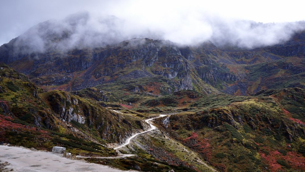
The pass is approximately 37 kilometers north of Tawang town, requiring a navigation through a winding mountain route that steadily climbs through dramatic Himalayan terrain. The surrounding landscape is dotted with pristine lakes, such as the Sangestar Tso, also known as Madhuri Lake.
The Strategic Significance of Bum La
It holds considerable strategic significance due to its location on the India-China border. This pass has been a natural corridor for cultural exchange and a strategic military position throughout history.
Bum La Pass on Map: Understanding its Geographic Position
When you locate Bum La Pass on a map, you’ll find it positioned in the northeastern extremity of India. The pass is part of a complex network of high-altitude passes in the Eastern Himalayas, with the Sela Pass to the south and the Tawang valley below. The route traverses through pristine alpine landscapes, offering panoramic views of the surrounding mountains.
Planning Your Journey to Bum La Pass
Embarking on a journey to the Pass requires meticulous planning due to its challenging terrain and regulatory requirements. As you prepare for your adventure, understanding the essential elements that will make your trip successful is crucial.
Essential Permits for Visiting Bum La Pass
To visit the Pass, obtaining the necessary permits is a must. The pass is a sensitive border area, and access is restricted. Ensure you have the required documentation before planning your trip.

Best Time to Visit: When is Bumla Pass Closed?
The best time to visit the Pass is during the summer months when the weather is relatively more favorable. However, the pass remains closed during the winter due to heavy snowfall and harsh conditions. Check the current weather conditions before you go.
Tawang to Bumla Pass Distance and Transportation
The distance from Tawang to Bumla Pass is approximately 37-40 kilometers, but the journey typically takes 2-3 hours each way due to the challenging mountain terrain. You must arrange transportation through local operators in Tawang, as only vehicles registered in Arunachal Pradesh with special permits are allowed on this route to the border.
- The road to Bum La is notoriously difficult, with sections that are little more than dirt tracks winding through steep mountain slopes.
- Your journey will take you through breathtaking landscapes, including high-altitude lakes and snow-covered passes.
- Plan for a full-day trip when visiting Bum La from Tawang, allowing ample time for checkpoints, weather delays, and stops at scenic points along the way.
As you plan your day trip to Bumla Pass, consider the time needed for the journey, the altitude, and the unpredictable weather. Your trip to Bumla Pass will be an experience to remember, with its challenging road and breathtaking vistas.
The Bum La Pass Experience
At Bumla Pass, the convergence of natural beauty and military importance creates a unique experience. As you reach this strategic location, you’ll be surrounded by breathtaking Himalayan landscapes while being part of a significant geopolitical context.
High-Altitude Adventure: Oxygen Levels and Acclimatization

At an altitude of 15,200 feet, Bumla Pass poses a significant challenge due to its high elevation. The oxygen levels are lower, making acclimatization crucial. Visitors must be prepared for the thin air, and it’s recommended to ascend gradually to avoid altitude sickness. Understanding the oxygen levels at Bumla Pass is vital for a safe and enjoyable trip.
Weather Conditions and What to Pack
The weather at Bumla Pass can be harsh and unpredictable. Visitors should be prepared for extreme cold, snow, and potential storms. Packing warm clothing, including insulated jackets, gloves, and sturdy boots, is essential. The unpredictable weather conditions demand flexibility and preparedness.
Meeting the Indian Army: Border Personnel Meetings
One of the unique aspects of visiting Bumla Pass is the opportunity to interact with the Indian Army personnel stationed there. You’ll learn about the Border Personnel Meetings (BPMs) between the Indian Army and China’s People’s Liberation Army. These meetings are crucial for maintaining peace and resolving border issues. The soldiers guarding the border share stories of their experiences and the challenges they face in the extreme weather conditions, providing a glimpse into the human dimension of border security.
As you visit the “Maitristall” or Friendship Point, you’ll observe the demarcation between India and China. The border area is a significant aspect of the Bumla Pass experience, offering insights into the geopolitical importance of this location.
Historical Significance of Bum La Pass
The historical significance of the Pass is multifaceted, reflecting both the cultural heritage and the geopolitical tensions of the region. As a strategic location, it has played a crucial role in the history of the Himalayas, serving as a border zone between India and China.
The Battle of Bum La Pass: 1962 Indo-China War
The pass witnessed one of the most significant conflicts in modern history during the 1962 Indo-China War. The Battle of Bum La Pass was a pivotal event, marking a tense chapter in the relations between India and China. This conflict highlighted the strategic importance of the pass and its border location.
Cultural and Political Importance
It is a place of profound cultural significance, where the Tibetan Buddhist world meets the Indian subcontinent. It has been a crossing point for centuries, used by pilgrims, traders, and cultural emissaries traveling from one side to the other. The pass represents a complex political reality in today’s world, where ancient cultural connections persist despite modern nation-state boundaries. Visitors can observe the shared Buddhist heritage reflected in prayer flags and religious symbols on both sides of the border. The journey to Bumla Pass is a way to understand the region’s intricate history and geopolitical dynamics.
As you visit Bumla Pass, you are walking in the footsteps of history, tracing the path that the 14th Dalai Lama took during his dramatic escape from Tibet in 1959. The pass continues to be a symbol of the region’s complex history and cultural heritage, offering insights into the geopolitical tensions that shape this part of the world. By understanding the significance of this place, you gain a deeper appreciation for the region’s history and its people.
Beyond Bum La: Nearby Attractions
Beyond the rugged terrain of Bumla Pass lies a wealth of untapped beauty waiting to be explored. The region is home to several other significant locations that are worth visiting.
Sela Pass

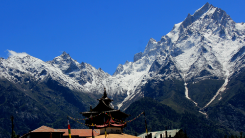
Sela Pass, another Himalayan marvel, is known for its picturesque landscapes and serene lakes. Located at an altitude of over 13,700 feet, it offers breathtaking views of the surrounding mountains. The pass is also home to the Sela Lake, a beautiful waterbody that remains frozen for most of the year.
Bomdila Pass vs. Bum La Pass
While both Bomdila and Bum La are significant mountain passes in Arunachal Pradesh, they have distinct characteristics. Bomdila, situated about 160 kilometers southwest of Bum La, is at a lower elevation and is more accessible, featuring a major Buddhist monastery. In contrast, Bum La Pass is directly on the Indo-China border and requires special permits. Understanding the differences between these passes can help you plan your itinerary more effectively.
Conclusion
Your trip to Bum La Pass is more than a day trip; it’s an immersion into one of the world’s most fascinating border regions. Here, geopolitics, military history, and natural beauty converge at the top of the world. The experience you’ll have, witnessing the dedication of border troops and absorbing the breathtaking Himalayan landscape, will stay with you. The combination of pristine lakes, snow-capped peaks, valley views, and crisp mountain wind creates an almost spiritual experience on this unique route.
Read more: Attractions
FAQ
Bum La Pass is situated at an altitude of 15,200 feet above sea level, making it one of the highest motorable passes in the world.
No, Bum La Pass is not open to tourists throughout the year. It is typically open from May to September, depending on weather conditions.
To visit Bum La Pass, you need to obtain a special permit from the Indian Army, which can be arranged through authorized tour operators.
Border Personnel Meetings are held at Bum La Pass between the Indian Army and the People’s Liberation Army to maintain peace and understanding along the India-China border.
Bum La Pass is approximately 37 kilometers from Tawang, and the journey takes around 1-2 hours by road, depending on weather conditions.
Some nearby attractions to Bum La Pass include Sela Pass, Madhuri Lake, and the town of Tawang, known for its stunning monasteries and natural beauty.
The best time to visit Madhuri Lake is during the summer months when the weather is pleasant, and the lake is accessible.
The high altitude of Bum La Pass can cause altitude sickness in some visitors. It’s essential to acclimatize properly and take necessary precautions.
